Friday, September 30, 2011

Fires in Northern Territory, Australia

Fires in Northern Territory, AustraliaLarge fires burned throughout Australia’s Northern Territory on September 30, 2011, when the Moderate Resolution Imaging Spectroradiometer (MODIS) on NASA’s Aqua satellite acquired this image. The fires are marked in red. Fire fighters were monitoring 21 fires, said news report, but many more are shown in the image. The fires are burning through thick grass in remote areas.

Fires in Northern Territory, AustraliaThe top image provides a closer view of three large fires around Alice Springs. The lower image shows a broader area of fire activity in central Australia. Smoke from the fires creating hazardous driving conditions in the Alice Springs region and forced some roads to close. Fires have burned nearly 150,000 square kilometers (58,000 square miles) in Northern Territory in September, said ABC News.

The fire season in 2011 is proving to be one of the most extreme in recent years. La NiƱa rains allowed thick grass to grow across Australia’s normally dry interior. The grass dried over the winter and is now an abundant source of fuel.

Ash and Lava Flows at Nabro Volcano

Satellite imagery suggests that the eruption of Nabro Volcano, which began in June 2011, continues. The volcano is located on the edge of the Danakil Desert, a remote and sparsely populated area on the border between Eritrea and Ethiopia, and few eyewitness accounts of the eruption are available. Orbiting instruments such as the Advanced Land Imager (ALI) aboard Earth Observing-1 (EO-1), which acquired these images, may be the only reliable way to monitor Nabro.

Ash and Lava Flows at Nabro Volcano

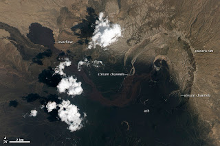
The images show the volcano in false-color (above) and natural-color (below) on September 28, 2011. Heat from vents in Nabro’s central crater is visible as a red glow in the false-color image. Another hotspot about 1,300 meters (4,600 feet) south of the vents reveals an active lava flow. A pale halo surrounding the vents indicates the presence of a tenuous volcanic plume. South of Nabro’s crater, the dark, nearly black areas are coated with ash so thick it completely covers the sparse vegetation. On either side of this region is a thinner layer of ash with some bright green vegetation (exaggerated in false-color) poking through.

Ash and Lava Flows at Nabro Volcano

In the natural-color image, the arid landscape is light brown where it is not covered by ash. The ash is black, while a fresh lava flow, spewed out in the last two weeks of June, is dark brown. More fresh lava flows surround the active vents. On either side of Nabro’s caldera, ephemeral streams have washed away the ash, leaving light-colored channels behind—a first sign of the erosion that will reshape, and eventually remove, what the eruption built.

Thursday, September 29, 2011

Flooding in India


Flooding in IndiaIn September 2011, two episodes of heavy rain in a 15-day period inundated the Indian state of Orissa. On September 27, 2011, the Hindustan Times reported that the second period of heavy rainfall had claimed 27 lives.
The Moderate Resolution Imaging Spectroradiometer (MODIS) on NASA’s Terra satellite captured the top image on September 27, 2011. For comparison, the bottom image shows the same area a year earlier, on September 28, 2010. These images show parts of the Brahmani and Mahanadi Rivers near the Bay of Bengal.

Flooding in IndiaBoth images use a combination of infrared and visible light to increase contrast between water and land. Water varies in color from electric blue to navy. Vegetation is bright green. Bare ground is earth toned. Clouds range from off-white to pale blue-green.
The most striking difference between these images is the large expanse of flood water around the city of Jajpur. Jajpur District was hardest hit by the second round of flooding in September 2011, being cut off from overland transportation, according to The Hindu. A significant area of flood water also occurs along the Mahanadi River east of Cuttack.
At the mouth of the Brahmani River, water in the Bay of Bengal is much lighter in color in 2011 than in 2010. This may result from increased sediment loads in the flooded river.
ABC News Australia linked the floods to unusually heavy rains late in the monsoon season. By September 27, the Hindustan Times reported, flooding had eased somewhat in parts of Orissa, but many villages remained marooned. The government planned to continue air drops of food and supplies to isolated areas.

Tuesday, September 27, 2011

Fire in the Sky and on the Ground

Fire on the Sky
Astronauts on the International Space Station (ISS) used a digital camera to capture several hundred photographs of the aurora australis, or “southern lights,” while passing over the Indian Ocean on September 17, 2011. If you click on the movie linked above, you can see the flowing ribbons and rays below as the ISS passed from south of Madagascar to just north of Australia between 17:22 and 17:45 Universal Time. Solar panels and other sections of the ISS fill some of the upper right side of the photograph.

Auroras are a spectacular sign that our planet is electrically and magnetically connected to the Sun. These light shows are provoked by energy from the Sun and fueled by electrically charged particles trapped in Earth’s magnetic field, or magnetosphere. In this case, the space around Earth was stirred up by an explosion of hot, ionized gas from the Sun—a coronal mass ejection—that left the Sun on September 14, 2011.

Fire on the Ground
The pressure and magnetic energy of the solar plasma stretches and twists the magnetic field of Earth like rubber bands, particularly in the tail on the night side. This energizes the particles trapped in our magnetic field; that energy is released suddenly as the field lines snap the particles down the field lines toward the north and south magnetic poles.

Fast-moving electrons collide with Earth’s upper atmosphere, transferring their energy to oxygen and nitrogen molecules and making them chemically “excited.” As the gases return to their normal state, they emit photons, small bursts of energy in the form of light. The color of light reflects the type of molecules releasing it; oxygen molecules and atoms tend to glow green, white or red, while nitrogen tends to be blue or purple. This ghostly light originates at altitudes of 100 to 400 kilometers (60 to 250 miles).

In the second image above, and in the last frames of the movie, light from the ground replaces the light show in the sky. Wildfires and perhaps some intentionally set agricultural fires burn on the continent of Australia, with smoke plumes faintly visible in the night sky. A gold and green halo of atmospheric airglow hangs above the horizon in the distance.

Friday, September 23, 2011

Every Flight is a Mission to Planet Earth

NASA's Flight MissionWhen the Space Shuttle Columbia first rocketed into space on a pillar of fire in April 1981, it was the maiden voyage of the world’s first re-useable spacecraft. Launched nine years after the last Apollo voyage to the Moon and six years after the joint Apollo-Soyuz Test Project, the shuttle was built to ferry humans and cargo into low-Earth orbit. It was part space plane, part rocket-propelled pick-up truck, and part orbiting launch platform.

NASA's Flight MissionThe Space Shuttle launched major satellites that helped revolutionize our study of the Earth. Its on-board experiments provided discoveries and new climatologies never before available. It provided for multiple flight opportunities for highly calibrated instruments to help verify results from satellites. Shuttle flights provided for on-orbit demonstration of techniques that helped pave the way for subsequent instruments and satellites. The shuttle enabled international cooperation.

Thursday, September 22, 2011

Approaching the 2011 Arctic Sea Ice Minimum

Approaching the 2011 Arctic Sea Ice Minimum

On September 9, the sea ice extent was very close to the record low set in 2007, according to the National Snow and Ice Data Center (NSIDC). Scientists at the University of Bremen, who use a slightly different method to calculate sea ice extent from AMSR-E measurements, declared that 2011 surpassed 2007, setting a new record low.

On September 9, sea ice covered 4.33 million square kilometers (1.67 million square miles), NSIDC reported. The 2011 low is 2.38 million square kilometers (919,000 square miles) below the average minimum extent measured between 1979 and 2000. Late season melt or a shift in wind patterns could still decrease the sea ice extent before the winter freeze-up begins.

In 2007—the last time sea ice reached similarly low levels—conditions were ideal for melt. Skies were clear, wind patterns thinned the ice, and warm air temperatures melted the ice. Weather patterns in 2011, by contrast, were typical. This means, NSIDC scientists say, that the ice was thin and spread out before the melting even started in the summer of 2011. It is a sign that Arctic sea ice is thinning. Indeed the last five years include the five lowest sea ice extents since records began in 1979, and much of that trend has been caused by global warming, says NASA Cryosphere Program manager Tom Wagner in his video interpretation of the 2011 sea ice record (43 MB MPEG-4).

Wednesday, September 21, 2011

Owens Lake in California

Owens Lake in California

This astronaut photograph highlights the mostly dry bed of Owens Lake, located in theOwens River Valley between the Inyo Mountains and the Sierra Nevada. Shallow groundwater, springs, and seeps support minor wetlands and a central brine pool. Two bright red areas along the margins of the brine pool indicate the presence of halophilic (salt-loving) organisms known as archaeans. Gray and white materials within the lake bed are exposed sediments and salt crusts. The nearby towns of Olancha and Lone Pine are marked by the presence of green vegetation, indicating a more constant availability of water.

The present-day Owens Lake was once part of a much larger lake and river system along the northeastern border of California and Nevada during the Pleistocene Epoch (about 3 million to 12,000 years ago). Melt water from alpine glaciers in the Sierra Nevada filled the regional valleys of the Basin and Range to form glacial lakes—ancestors of the now-dry lakebeds (or playas) of Owens, Searles Lake, and China Lake.

While Searles and China Lakes dried out because of regional changes to a hotter and drier climate, Owens Lake became desiccated largely due to the diversion of the Owens River in the early 20th century to serve the needs of Los Angeles, 266 kilometers (165 miles) to the south. Following complete desiccation of the lakebed in 1926, significant amounts of windblown dust were produced. Residents of the now largely abandoned town of Keeler (on the eastern side of the lake) coined the term “Keeler fog” to describe the airborne dust.

In addition to adverse health effects on local residents, dust from Owens Lake has been linked to reductions of visibility in nearby national parks, forests, and wilderness areas. Recently, the City of Los Angeles has undertaken efforts to control dust evolution from the lakebed.

Tuesday, September 20, 2011

Aland Islands

Aland IslandsThe Aland Islands (also known as the Aaland Islands) lie at the southern end of the Gulf of Bothnia, between Sweden and Finland. The archipelago consists of several large islands and roughly 6,500 small isles, many of them too small for human habitation.

Aland vegetation is a combination of pine and deciduous forest, meadows, and farmed fields. On nearly every island, however, the region’s characteristic red rapakivi granite appears.

Modern residents of Aland cut and use the granite in buildings and pavement, but much earlier, ice sculpted these rocks. About 20,000 years ago, a massive ice sheet stretched over Scandinavia and the Gulf of Bothnia, and glacial action gradually wore the granite smooth.

The granite in this region is actually far older than the glaciers that smoothed its surface, having formed in the Proterozoic Era. The rapakivi was deposited tens of millions of years before the first amphibians crawled out of water and onto land, and hundreds of millions of years before the first dinosaurs evolved.

Monday, September 19, 2011

Solar Activity Subsiding - Auroras Ablaze

Solar Activity SubsidingSolar activity is subsiding after last week's flurry of strong flares from sunspot 1283. The sunspot remains capable of M-class eruptions, but Earth would be unaffected by further blasts as the sunspot rotates over the sun's western limb.
A coronal mass ejection (CME) struck Earth's magnetic field on Sept. 9, sparking more than 18 hours of bright auroras around the Arctic Circle. In the United States, Northern Lights were spotted as far south as Michigan, Washington, Wisconsin, Vermont, Montana, Maine, Minnesota and North and South Dakota. A similar display could be in the offing on Sept. 12-13 when another CME from sunspot 1283 is expected to sail past Earth.

Friday, September 16, 2011

Meteor Likely Cause of Southwest U.S. Light Show


A meteor is the most probable cause of a bright, colorful fireball witnessed by people in a wide swath of the southwestern United States, according to Don Yeomans, manager of NASA's Near-Earth Object Program Office at JPL.

Residents from Southern California to Arizona to Las Vegas reported seeing a streak of light move rapidly from west to east around 7:45 p.m. PDT on Wednesday, Sept. 14.

"We're virtually certain this bright display was caused by a meteor, probably the size of a baseball or basketball, that burned up in Earth's atmosphere. It appeared much larger because of the heated and glowing atmosphere along its path," said Yeomans.

Many eyewitnesses described seeing brilliant colors of blue, green and orange. Yeomans said the blue or green colors indicate the meteor contained nickel or magnesium, while orange would mean the object was traveling relatively slowly for a meteor, but still moving a few miles per second.

A meteor is a small fragment of an asteroid. Yeomans said that similar fireballs from asteroids enter Earth's atmosphere every week or so, but they usually take place over the ocean or in a sparsely populated area.

This time, Yeomans says, "The fireball was very bright and provided a harmless but memorable light show for people in numerous cities and towns in the southwestern states."

Thursday, September 15, 2011

Sunspot 1283 Bristling With Flares: An X1.8 and An M6.7

sun spot
A strong geomagnetic storm is in progress following the impact of a CME around 7:30 EDT on Sept. 9th. This could be the first of several hits from a series of CMEs expected to reach Earth during the weekend, related to the sunspot 1283 flares during the week. High-latitude sky watchers should be alert for auroras after nightfall.

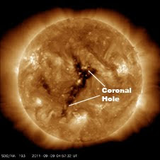
A high-speed solar wind stream flowing from a large coronal hole should reach Earth on Sept. 11-12 sparking even more aurora.

A third and fourth flare have erupted from sunspot 1283. The third came on September 7 at 6:36 PM ET, and was categorized as an X1.8 by the GOES spacecraft, making it the second X-class flare within 24 hours. There was a coronal mass ejection (CME) associated with all three of the recent flares, but none of them are expected to travel directly toward Earth, and the first two were unlikely to cause aurora. NASA computer models suggest that the latest CME may give a glancing blow to Earth on the morning of September 11, and might create some aurora.

The fourth flare from this same sunspot was detected by GOES at 11:36 AM ET on September 8. This was an M6.7 flare, considered moderate.

Wednesday, September 14, 2011

Lava Flow on Kizimen Volcano

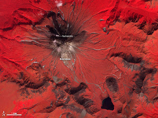
Lava Flow on Kizimen VolcanoA prominent lava flow descends the eastern flank of Kamchatka’s Kizimen Volcano in this false-color satellite image acquired on September 4, 2011 (top). An image of the peak from September 6, 2009 (lower), shows the extent of the changes that have occurred since Kizimen began erupting in late 2010.
Volcanic deposits (colored brown) have covered much of the vegetation (red) on the slopes of the volcano, especially to the east. Likewise, material has filled rivers and streams around the volcano. A modest volcanic plume rises from Kizimen’s summit, accompanied by a smaller plume from a fumarole to the northwest.


Lava Flow on Kizimen VolcanoThese images illustrate the growth of a stratovolcano: layers of lava flows alternate with layers of “volcanic ash, cinders, blocks, and bombs.” Unlike fluid hawaiian-style lava, the flow on Kizimen is a block-lava flow, so viscous it’s almost solid. As the flow slowly advances down the east side of the volcano, the surface crumbles, sending boulders, rocks, pebbles, and other material tumbling into the valley below.
In less than a year, this rubble piled high enough to block several drainages, and a new lake was formed. Ash and fine sediment color the lake brilliant blue, in contrast to the nearly black shade of the lake in 2009. Famous stratovolcanoes include Mount St. Helens, Mount Fuji, and Popocatepetl.

Monday, September 12, 2011

Shrinking Aral Sea

Shrinking Aral Sea

In the 1960s, the Soviet Union undertook a major water diversion project on the arid plains of Kazakhstan, Uzbekistan, and Turkmenistan. The region’s two major rivers, fed from snowmelt and precipitation in faraway mountains, were used to transform the desert into fields for cotton and other crops.

Although irrigation made the desert bloom, it devastated the Aral Sea. This series of images from the Moderate Resolution Imaging Spectroradiometer (MODIS) on NASA’s Terra satellite documents the changes throughout the past decade. At the start of the series in 2000, the lake was already a fraction of its 1960 extent (black line). The Northern Aral Sea (sometimes called the Small Aral Sea) had separated from the Southern (Large) Aral Sea. The Southern Aral Sea had split into eastern and western lobes that remained tenuously connected at both ends.

By 2001, the southern connection had been severed, and the shallower eastern part retreated rapidly over the next several years. Especially large retreats in the eastern lobe of the Southern Sea appear to have occurred between 2005 and 2009, when drought limited and then cut off the flow of the Amu Darya. Water levels increased in 2010 after the drought broke and then began to dwindle again in 2011.

In a last-ditch effort to save some of the lake, Kazakhstan built a dam between the northern and southern parts of the Aral Sea. Completed in 2005, the dam was basically a death sentence for the southern Aral Sea, which was judged to be beyond saving. All of the water flowing into the desert basin from the Syr Darya now stays in the Northern Aral Sea. Between 2005 and 2006, the water levels in that part of the lake rebounded significantly and very small increases are visible throughout the rest of the time period. The differences in water color are due to changes in sediment.

Thursday, September 08, 2011

Wildfire Smoke Plumes over Texas

This panoramic view of east-central Texas on September 6, 2011, highlights numerous smoke plumes caused by wildfires burning across the state. The image was taken by astronauts aboard the International Space Station (ISS), who used a short focal-length lens (12 mm) to capture a wide field of view. Smoke plumes are clearly visible to the east of Austin; to the north of Houston; to the northwest of Lake Sam Rayburn and Toledo Bend Reservoir; and to the west of Shreveport, Louisiana. Diffuse smoke is moving offshore into the Gulf of Mexico at image bottom. Part of an ISS photovoltaic radiator panel is visible at image top center.

Record-setting drought conditions have affected much of Texas since early 2011drying out both forest and grassland and providing ample fuel for wildfires. Relatively high winds and low humidity levels have also contributed to the rapid spread and expansion of fires. According to a report dated September 7, 2011, the Texas Forest Service had responded to 172 fires affecting an area of 546.53 square kilometers (135,051 acres) over the preceding seven days. Fires near Bastrop (to the east of Austin) had destroyed 785 homes as of September 7, 2011.

Wednesday, September 07, 2011

India-Pakistan Borderlands at Night

Clusters of yellow lights on the Indo-Gangetic Plain reveal numerous cities large and small in this astronaut photograph of northern India and northern Pakistan. Of the hundreds of clusters, the largest are the capital cities of Islamabad, Pakistan, and New Delhi, India. (For scale, these metropolitan areas are approximately 700 kilometers or 435 miles apart.) The lines of major highways connecting the cities also stand out. More subtle, but still visible at night, are the general outlines of the towering and partly cloud-covered Himalayas to the north.

A striking feature is the line of lights, with a distinctly orange hue, snaking across the center of the image. It appears to be more continuous and brighter than most highways in the view. This is the fenced and floodlit border zone between India and Pakistan. The fence is designed to discourage smuggling and arms trafficking. A similar fenced zone separates India’s eastern border from Bangladesh (not visible).

India-Pakistan Borderlands at NightThis image was taken with a 16 mm lens, which provides the wide field of view, as the International Space Station (ISS) was tracking towards the southeast across India. The ISS crew took the image as part of a continuous series of frames, each with a one-second exposure time to maximize light collection. Unfortunately, this also causes blurring of some ground features.

The distinct, bright zone above the horizon (visible at image top) is airglow, a phenomena caused by excitation of atoms and molecules high in the atmosphere (above 80 kilometers, or 50 miles altitude) by ultraviolet radiation from the Sun. Part of the ISS Permanent Multipurpose Module and a solar panel array are visible at image right.

Monday, September 05, 2011

NASA’s Space Shuttle Program - Spanning 30 Years of Discovery

NASA's space shuttle fleet began setting records with its first launch on April 12, 1981 and continued to set high marks of achievement and endurance through 30 years of missions. Starting with Columbia and continuing with Challenger, Discovery, Atlantis and Endeavour, the spacecraft has carried people into orbit repeatedly, launched, recovered and repaired satellites, conducted cutting-edge research and built the largest structure in space, the International Space Station. The final space shuttle mission, STS-135, ended July 21, 2011 when Atlantis rolled to a stop at its home port, NASA’s Kennedy Space Center in Florida.

As humanity's first reusable spacecraft, the space shuttle pushed the bounds of discovery ever farther, requiring not only advanced technologies but the tremendous effort of a vast workforce. Thousands of civil servants and contractors throughout NASA's field centers and across the nation have demonstrated an unwavering commitment to mission success and the greater goal of space exploration.

Saturday, September 03, 2011

Sun Rising on the Final Shuttle Mission

Silhouetted against the Earth, Atlantis flies into the rising Sun in this photograph taken by an astronaut on the International Space Station on July 19, 2011. On July 20, the shuttle undocked from the station for the final time and began preparations to return home. During their 13 days in space the shuttle astronauts supplied the International Space Station with a new logistics module, tested tools, technologies, and techniques to refuel satellites in space, and collected old equipment from the space station.

Atlantis is scheduled to land at Kennedy Space Center at 5:56 a.m. local time on July 21, concluding NASA’s 30-year space shuttle program. In addition to the science the shuttle and earlier programs enabled, human space flight has given us a unique view of planet Earth, which includes the now iconic spectacle of Earth rising over the Moon taken during the first lunar landing on July 20, 1969, and the photographs taken from Atlantis during its last full day in space on July 20, 2011. In fact every flight is a mission to planet Earth as described in the Earth Observatory’s tribute to the shuttle program.
Astronaut photograph ISS028-E-017845 was acquired on July 19, 2011, with a Nikon D2Xs digital camera using a 14 mm lens, and is provided by the ISS Crew Earth Observations experiment and Image Science & Analysis Laboratory, Johnson Space Center. The image was taken by the Expedition 28 crew. The image has been cropped and enhanced to improve contrast. The animation has been motion-stabilized.

Friday, September 02, 2011

Rising Water along the Ganga River

Flooding in more than 1,000 villages in Bihar forced residents from their homes by late August 2011, the Indo-Asian News Service reported. After two years of drought, the Kosi River and Ganga (Ganges) Rivers were rising rapidly.

The Moderate Resolution Imaging Spectroradiometer (MODIS) on NASA’s Terra satellite captured these images of a stretch of the Ganga, or Ganges, River around Patna August 30, 2011 (top), and June 23, 2011 (bottom). These images use a combination of infrared and visible light to increase contrast between water and land. Water ranges in color from electric blue to navy. Vegetation is green. Clouds are pale blue-green.

Water often rises along the Ganga during monsoon season, which typically lasts from June to August. In August 2011, however, waters rose high enough to pass the danger mark in multiple locations. In the image from August, the swollen river has spilled onto floodplains to the north and south. The Indo-Asian News Service reported widespread damage to crops as well as destroyed homes.